Terrain Height Tool #
The Terrain Height Tool is where you add a third dimension to your tracks! You can raise or lower the terrain, and even expose water.
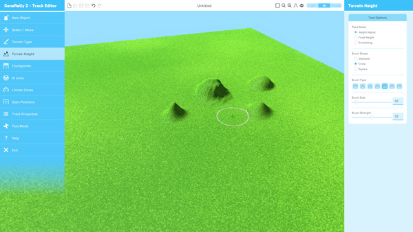
Paint Mode #
Here you can pick from three different height-adjustment modes:
- Height Adjust - this allows you to raise (Left Mouse) or lower (Right Mouse) the terrain by clicking and dragging/holding.
- Fixed Height - this allows you to set an area of the terrain to an exact height. It also features a Height Pick mode, where you can click anywhere on the terrain to sample a height, and then paint with it.
- Smoothing - this mode allows you to smooth out rough patches of your terrain, which can be essential for making a nice smooth track to drive on!
There are also three brush shapes currently available: Diamond, Circle, and Square.
The Brush Type determines in what shape the ground will be raised or lowered. Combined with the Brush Shape, there are many possible options!
The Brush Size and Brush Strength can also be adjusted.
Water #
To learn more about how to get water in your tracks, see the Water Level section on the Track Properties page.
Import / Export #
You can export the height map to a PNG file to work on it in an external editor and then re-import it to the Track Editor. In order to use this feature, your track must already have been saved. Then, when you press the “Export PNG” button, a file called “TrackName.height.png” will have been created alongside it in your Tracks folder - you can edit this in any normal graphics software. When you are finished, save the file, and press “Import PNG” to load the height data back into the Track Editor.
Important Note #
Due to the high level of detail in GeneRally 2’s height system, the height data cannot be accurately represented in a simple grayscale PNG file. As a result, when using the “Export PNG” button, some amount of information about the heights in the Track Editor will be lost.
When importing height maps using the “Import PNG” function, you can use the terrain height smoothing tool to help make up for this limitation.